A hike on the Pacific Crest Trail

Hi everyone. This blog will chronicle my walk along the Pacific Crest Trail. Snoop around and find out about who I am, why I'm doing this, what I'll be bringing, and follow along as I hopefully make it all the way from Mexico to Canada.

Sunday, August 30, 2015

Post trip update

So I've been back at home a few days now, and it is still feeling like the right decision to get off the trail when I did. I've been seeing photos online of people who have made it to the Canada border over the last few days, and these have stirred in me some sense of longing for getting to accomplish the whole trail in one season. But in the backgrounds of all these photos is the unmistakable gray haze of forest fire smoke, and seeing this has cemented in me the feeling of not wanting to hike through the beautiful Washington when the sky is choked with smoke. And of course being back with Libby and Abbey is so wonderful and has filled an emptiness that had grown throughout the hike. I've been spending a lot of time in the ocean to distract myself and my body from not being on the trail, and this seems to be working. I am really excited about returning to finish the trail at some point, but doing those miles now, when conditions and my body and my emotions are not at their optimum, just to say I did it in one season, has grown to feel like doing those miles for other peoples' reasons, not my own. If I can't enjoy the miles in the way I want to, then I'd rather not invest all that time and pain and loneliness in doing them. I'm really lucky to have so many amazing things to do with my time, and to have the ability to do them on my own schedule and pace.


Climbing from Portland airport, looking north past lots of haze to a big plume of smoke somewhere in WA.


Over the next week or so I will do some reviews of the gear and other things I used and put together a few tips for doing the hike. And some time in the future I will be back out there on the trail, looking for birds and enjoying views and taking my time to finish Washington.  

August 25. Day 116

Salvation Spring to Cascade Locks (mile 2144.4)
Miles hiked: 9 on PCT; 15.4 on Eagle Creek alternate.


Woke in the dark and took my time making coffee and packing as the orange glow grew on the eastern horizon. The shortening of the days is particularly noticeable here in the deep dark forest, where the day's light didn't reach until nearly 6; it seems like only a few days ago that I was starting to hike at 5:30 with no headlamp.


The trail continued along the ridge I started on yesterday with occasional views back toward Hood and eventually views north across the Columbia River Gorge into Washington. I had my granola on an open hillside with a panorama spreading from Mt. St. Hellens in the northwest to Rainier way off to the north and Adams close across the border to the northeast. It was clear and beautiful where I was sitting but way to the north I could see a bank of smoke and close by near Mt. Adams a new plume from the building fire that by tomorrow would close 24 miles of trail there. I took my time with this brunch, allowing my mind to wander back over memories of the hike and trying to be conscious of my emotions on this last day of hiking. I expected to feel some sadness about the end, but it did not come. Rather, I in stead felt a very happy satisfaction with the experience I've had. To steal one of Libby's metaphors, it is as if I've been sitting down at a wonderful meal, and I have eaten just the right amount of delicious foods, but have not stuffed myself to the point of discomfort. And now I push back from the table with the satisfaction of having taken just the right amount from this feast. I know the trail will always be there for me to finish in the future, and I feel very happy with how much of it I have walked thus far.

Looking in to Washington

Shortly after brunch I turned off the PCT onto the popular Eagle Creek alternate, which is about a mile shorter than the official PCT and descends down a beautiful narrow canyon past a series of several waterfalls and cascades and slow lazy deep blue pools. The trail began steeply, much steeper than the PCT ever is, and my quads and shin muscles burned with the descent. But then the trail made it down to creek level in the canyon and the grade lessened. Big trees with mossy bases grew along the steep rocky slopes and the creek twisted downward through the narrow bottom of the canyon. The trail tread was rocky and there were more and more day hikers to pass, so progress was somewhat slower than I'd come to be used to on the PCT. I passed by the famous Tunnel Falls, where the trail passes behind a 100+ foot waterfall through an impressively carved tunnel. Water dripped from the ceiling and ferns and moss crept in from each end as far as the light would allow. A little later when the trail was about 10 feet above a pool with riffles at the lower end I got to stand and watch a Dipper swimming like a duck from one rock to another looking for snacks.

Two views of Tunnel Falls


Soon the rushing rumble of Interstate 84 and the trail tracks of the Columbia Gorge grew louder and I was back to the world of fast moving shiny objects. I followed the Gorge Trail a few miles east along this corridor of transit to the little town of Cascade Locks, where I promptly got a bunch of peaches from a fruit stand and went to town on them. Cascade Locks is a really hiker friendly little town that the trail passes right through. I got my resupply box at the post office and pulled out a few snacks for the trip home and put the rest in the hiker box, then found my way to the campground shower and scrubbed off. Next it was to the local brew pub right on the river where awesome locals apparently buy an extra beer and put a chip in a jar, which hikers can then pull out to redeem; pretty great spot.

Swimming Dipper.

It was still fairly early so I figured I'd try getting a ride to the airport this evening, but had no luck standing for an hour or so and eventually I decided it was to late to try and get a plane ride tonight and went back to the brew pub for some dinner. After eating while the sun set and the old paddle wheeler took people for a ride up the river, I made my way back to the campground and laid out my stuff for what ended up being a fitful night of short naps between the frequent passing of trains on the tracks only a hundred feet away.


Birds:
Hermit Thrush
Red-breasted Nuthatch
Oregon Junco
Hermit Warbler
Unk. Empid
Red Crossbill
Pacific Wren
Pileated Woodpecker
Chickadee - went through habitat/elevation of Mountain and Black-capped, but never got good looks.
Hairy Woodpecker
American Dipper
American Robin
Steller's Jay
Osprey
Bald Eagle

August 24. Day 115.

Timberline Lodge to Salvation Spring (mile 2116.1)
Miles hiked: 21.6


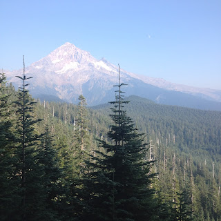
Laid in bed and watched the sun rising soft pink and slow through some thin clouds and smoke and lighting the cold pewter slopes of Mt Hood, catching up on yesterday's journal and waiting for the breakfast buffet to start at 7, which seems awfully late nowadays. There was quite a gaggle of hikers in the lodge, taking advantage of the big comfortable chairs and electrical plugs and vats of great coffee and overall awesome setting. The buffet was indeed not to be missed, with big platters of cheesey eggs and pancakes and ham and sausage and breakfast potatoes, plus a waffle station with whipped cream and various fruits for toppings, fruit smoothies, yogurt, granola, fruit, and probably some other stuff that I didn't see. I'm not properly equipped for all you can eat buffets, because even though my metabolism is ramped up and I can eat 5 or more full meals in a day now, I can't really eat a whole bunch in one sitting. I had a full plate then waited around as long as I though I could get away with and had another. This left me so full and lazy-feeling that I ended up sitting around the lodge until noon or so, afraid to put on my pack and tighten the waist belt.

Hikers taking over the lodge.

Once I got walking, the trail continued contouring around the west slopes of Hood, dropping down into the deep, steep and crumbly-loose canyons of a few creeks then climbing back up onto the forested slopes. There were some spectacular views at the edges of theses canyons, with the creek cutting down into hard basalt and glued-together ash in places to make slot canyons with little ribbons of waterfall. Around the west-north-west side of the mountain we dropped down into the big canyon of the Sandy River, the crossing of which ended up being thigh-deep rather than the expected shin-deep. An alternate trail took me along the base of Ramona Falls, where a side creek cascades over a cliff and spreads out into a broad fan over steep steps in the rock face. This side creek then led the trail down through a sylvan wonderland with big trees I still haven't learned leaning in over the banks of the creek and moss growing thick and soft on all surfaces.


The hiking felt easy all day, as if a weight had been lifted from my shoulders. I had finally decided the night before that I would end the hike when I got to Cascade Locks. This may seem a bit abrupt since I haven't really written about it, but I've been mulling it over for a week or so and a range of factors have come together in making this decision. It is not a decision I make lightly, but with all the factors in play, it has become an easy decision. The main factor is that this has come to be too long away from Libby, and Abbey. It is not just the time away on this trip, but also for the 4-5 months before the hike we were living in different states due to school and work, with only a couple few-week chunks spent together. Being apart that much is just a drag, and all the great scenery and experiences I've been seeing and having have been muted and dulled by my missing them.

Ramona Falls

Additionally, the big fires in Washington have closed sections of the trail and the situation remains volatile and unpredictable. Not being able to currently hike all the miles to the border (at least not on trail; there are apparently some long road walk detours) has somewhat taken the appeal out of continuing through the foot pain and missing home just to say I hiked a few hundred more miles in one season. And most importantly regarding the fires, I've really gotten my fill of hiking in heavy smoke. Not only does it tighten my throat and burn in my eyes, but it takes away one of the most important aspects of the hike for me: being able to look out over long views and really see how the landscape is put together. It was a real disappointment to hike the Trinity Alp and Marble Mountains in such thick smoke, and from what I've heard and photos I've seen of WA, I really don't want to do that again. Without being able to see and really experience the landscape, the additional miles have become sort of meaningless to me; I don't want to reduce this experience to some sort of treadmill exercise, and that is sort of the direction it was headed, at least for me. So I have decided to save Washington for another time, when I really want it, when I can slow down and see more and maybe bring my big camera, and when it is not on fire and smoke-clogged.

The trail crossed a narrow log over a churning brown stream and climbed up out of the Sandy River canyon to regain a ridge that would eventually lead all the way to the final descent to Cascade Locks tomorrow. The sun was now dipping low to the west and now and then through gaps in the trees I could see the big, soft pink Mt Hood, now from the northwest. The day's walking had brought me all the way around this big mountain. I hiked until dark, wanting to make tomorrow's hike a few miles shorter so I would have time to take it slow to enjoy what is supposed to be a spectacular bit of trail, and also to provide time for reflection on the trip.


I set up camp near a spring on a steep hillside as the day's last light faded from the trees. I thought I might feel some sense of significance with this being my last night on the tail, but it ended up feeling like just another night on the trail. It was not a particularly stunning campsite, with no real view of anything. As I fell asleep I decided that this was as it should be; to have the last night feel just as all the others, I decided, was just the way I wanted this night to be.


Birds:
Oregon Junco
Northern Flicker
Gray Jay
Varied Thrush
Red-tailed hawk
Red Crossbill
Red-breasted Nuthatch
Warbler- Nashville or MacGillivray's; just a quick look
Pacific Wren
Common Raven
American Dipper

Wednesday, August 26, 2015

August 23. Day 114.

Mile 2071.2 to Timberline Lodge (mile 2094.5).
Miles hiked: 23.3.

A couple Great-horned Owls were carrying on near me for a while and I had some trouble getting back to sleep so read a while. Then when the alarm went off I was moving pretty slow and ended up just sitting in my bag drinking coffee and clipping my finger nails and listening to some coyotes chatting in the middle distance. Got walking a little after 6 and promptly ran in to Morning  Star and Cookie Monster and talked with them a while. But no worries; don't have too many miles to do today. 

Classy

The trail circled around Timothy Lake with Osprey and Kingfishers out doing morning chores then crossed a small inlet stream where I flushed some Mallards from an eddy. It was smokey again, and the occasional views out through the thick forest were hazy and obscure. After the lake I began the long gradual climb up the lower flanks of Mt Hood. For 15 miles or so it was up and up and up but always gently graded like the PCT is. The trees were big and growing close and rhododendrons were the main understory plant. 

Forest details:


Finally after crossing a couple small highways with lots of weekend backpackers the trail climbed up out the forest and there emerging from the haze like a ship in the fog was Mt Hood. The upper slopes were bare and desolate looking with a few dirty glaciers and foamy, silty cappuccino streams charging straight down the mountainside carving deep canyons in the loose sandy soil. The trail was also loose and sandy, and the final approach to Timberline was like climbing a mile of sand dune. 

Hood emerges from the smoke. 


I got down to the lodge which is a big old wood and stone structure and had a little wash-off in the hiker shower which isn't much more than a converted ports-potty with a hose running in through the top to a shower head. After that it was in to the lodge for some beers in a big airy lobby with Hitch Bait and Pops and Wallaby (camped with him at kickoff but haven't seen him since) and Barely and Sherlock and several others. Then we moved down into a little sliver of basement where we got awesome pizza and more beers while the room got filled with oven smoke and our eyes watered and we kept laughing and telling stories. Finally it was time to leave and we straggled out and back up the hill a couple hundred yards to the little patch of trees where we're all camped. 


Birds:
Great-horned Owl
Oregon Junco 
Pacific Wren 
American Robin 
Hermit Thrush 
Brown Creeper 
Osprey 
Red Crossbill 
Belted Kingfisher 
Gray Jay 
Mountain Chickadee 
Mallard 
Steller's Jay 
Northern Flicker 
Mountain Bluebird 
Clark's Nutcracker 

August 22. Day 113.

Cigar Lake to mile 2071.2.
Miles hiked: 29.1.


The wind grew overnight and even though it was around 50 degrees, I kept my down jacket on all night for only the 5th or 6th time of the trip. He wind blew smoke in from somewhere, and for some reason I had dreams about people burning trash. In the morning the wind was still blustery and cool and gusting up toward 25 mph. Streamers of reddish-brown smoke curved around a nearby peak, and a haze was thickening in the air. 

Olallie Lake and Jefferson from the north. 

I stopped in at Olallie Lake to check out the scene. The store wasn't open yet and I couldn't think of anything I wanted to buy anyway, so I just said good morning to the few hikers waiting around and kept going. The wind now built to gusts over 30 mph, kicking up dust from the trail and shaking needles from the trees. The thickening smoke began to ache in my eyes. I flushed what I think was a juvenile Northern Goshawk, but otherwise it was a quiet day for birds. 


The rest of the day was spent walking through more easy flattish forest with thick smoke. Visibility dropped down to just a mile or two and the sun was muted through the day. The trees were again shaggy with moss and lichen and most carpeted the ground in many places. 


I leapfrogged with several other hikers: Sherlock, who I've seen off and on since Kennedy Meadows; Hitch Bait and Pops, who I talked with once near Mammoth and saw briefly at Echo Lake but haven't seen since; Cooky Monster and Morning Star, from Belgium and just met today; and a few others whose names I didn't get.  At the last water break of the day, where everyone had stopped for a rest, there was talk of the breakfast buffet at Timberline Lodge, and that everyone's plan was to go another 8 miles tonight to a campground with water spigots, then do a short 24ish miles tomorrow to be there for the buffet the next morning. I had been planning to pass by Timberline tomorrow, but I've been feeling a bit slow and I hear the buffet is not to be missed, so I decided to slow it down a bit and adopt the same timeline. We separated for the evening hike and when I got to the campground I realized it was the weekend and found all the sites taken and couldn't find the hikers that were in front of me. I could see their tracks leading down the spur trail to the campground, but didn't find them there and didn't see tracks leaving. Maybe they were all inside one of the giant car camping tents that were set up everywhere. 

I filled some water bottles then did just another 0.1 miles or so to the next camp spot I could find. With the moss and other understory foliage in this wetter forest, I've been needing to find previously-used campsites, unlike in the drier areas where pretty much any little flat space would be free of living things. I ate too much polenta too quickly and got nauseous and thought maybe I was getting sick, but it passed and I flopped down into bed without any desert. The moon, now waning and nearing half full, glowed orange in the smoke and drifted behind tall broad tree trunks. 


Birds:
Oregon Junco 
Mountain Chickadee 
Northern Goshawk?
Golden-crowned Kinglet 
Red-breasted Nuthatch 
Gray Jay 
Common Nighthawk 

August 21. Day 112.


Rockpile Lake to Cigar Lake (mile 2041.1).
Miles hiked: 28.8.

Slept through my alarm since it was turned down from being in a house with other people, but still got hiking by 6.  The trail quickly crossed a saddle where the wind was blowing thin wisps and filaments of cloud over the ridge from west to east. I walked quickly through the moist, heat-sucking wind, feeling it's cold seep through my clothes to my skin the way wind feels when your out on the ocean early in the morning. After crossing the saddle I turned back and could see the cloud forming on the west slopes of Rockpile Peak as the humid western air was blown up and over and cooled and condensed, then fading into shreds as it crossed over the crest and sunk back down into the dry eastern air. I could almost sense the moisture being sucked right out of the air by the parched trees rising up into the fading cloud. Off to the east, the sun rose orange and red through wispy clouds. The peak of Mt Jefferson came into view as I rounded bends in the ridge. But soon it too was growing its own blanket of cloud. A Golden Eagle soared over headed north, with some other large hawk that I couldn't figure out lazily mobbing it as they went along. 


The trail spent much of the morning wrapping around the steep western flank of Jefferson. This was mostly in forest of tall trees shaggy with moss and thick understory of blueberry bushes turning red and rhododendrons with drooping leaves and no flowers left. The morning's fairly efficient travel was interrupted only by Russell Creek, silt-laden and tumbling steeply down from one of Jefferson's glaciers, roiling around slippery looking rounded boulders and pouring quickly through spouts between frothy pools of uncertain depth. I struck out upstream looking for a good place to cross, and not really finding one in 100 or so yards I just sort of hopped across some slightly-submerged rocks where the stream split into a couple narrower channels. 

Crossing doesn't look too bad from up here, but gave me a bit of trouble. 

Mt Jefferson 


I lunched beside the gently lapping waters of Scout Lake, set in Jefferson Park, a big flat bench on the north side of Jefferson, with canyons dropping off to east and west and ridge rising to the north. I laid my sit pad out on a sandy beach and made my little cheese and salami burritos then put on my pants and down jacket against the chill wind and had a nap. 


From Jefferson Park the trail climbed north up a slope to regain the ridge as it dirt rose then dropped down to the north of the big Jefferson with its crevassed glaciers spewing milky streams down the mountain side. I crossed a small east-west running ridge at the top of this climb and suddenly there was Mt Hood way up to the north another 50 trail miles away, standing tall and bare with snow and glaciers and alone with just shorter forested hills all around. Cresting this ridge and looking back, Jefferson looked much closer without the Park visible. 


The next several miles I wound down a mostly barren and beautiful sun-alpine ridge with clusters of stunted trees here and there and lots of rock cropping out all over the place and little forbs growing sparsely in the dry shallow soil. All the while Hood was out there near the horizon, and in the low space just beyond flowed the Columbia River. 

The trail finally dropped back down into forest, and I continued another couple hours to set up my little cowboy camp near the little Cigar Lake with its water a few feet below normal. 


Birds:
Oregon Junco 
Red-breasted Nuthatch 
Golden Eagle
big hawk
Northern Flicker 
Steller's Jay 
American Robin 
Cooper's Hawk

August 20. Day 111.


Santiam Pass to Rockpile Lake (mile 2012.3).
Miles hiked: 13.9.

Puttered around a couple hours organizing things and trying to figure out what's going on with the fires and trail closures in Washington. Then Allyson drove me all the way back to the trail and I got hiking by around 12:30


The trail climbed up through some old burned forest with views back south through the bleached trunks at the Three Sisters and Mt Washington. It was a beautiful day with really clear light blue mid day sky and the distant peaks were crisp and seemed so close. I skirted around he west side of Three Fingered Jack, a small but dramatically eroded old volcanic core. Down to the west little blue lakes  shimmered in the sun like gems tossed out on a green carpet.

Looking south toward the Three Sisters area. 

Around the north side of Three Fingered Jack the trail regained the crest ridge and followed it for the rest of the day. Through breaks in the trees I could see back south across a huge panorama, including the low plains where Sisters and Bend are, Black Butte, Broken Top, Middle and North Sisters, Washington, and Three Fingered Jack. Such an incredible view, perhaps the best yet in Oregon. Wind blew across the ridge, keeping it cool and making noises like human voices in the old burned snags. I saw a couple southbounders and some other thru hikers and backpackers at a water source, but otherwise had the trail to myself. 

Three-fingered Jack

I had dinner at Rockpile Lake, a little shallow pool stuck in a notch between the ridge and a side peak, with the intention of hiking a couple more miles after eating. But the meal took longer than I was expecting and I just ended up setting up camp there. I did my camp chores then snacked and wrote and read while the sliver moon played peekaboo behind dark tree trunks. 


Birds:
Northern Flicker 
Yellow-rumped Warbler 
Mountain Chickadee 
Oregon Junco 
Bluebird - I think Western, but not a good look 
Common Raven 
Chipping Sparrow 
Clark's Nutcracker