Miles hiked: 24.4.
I had a few more chores to do after writing last night (sew button on pants, make hole in water bottle lid to back flush my water filter), so I didn't get to sleep until a little after 10, which is late for hikers.
Got moving around 4:30, had my coffee pre-made and just drank it cold to save the time of heating water the. Letting he stove cool down and packing it up. It still took 25 minutes to get hiking though, because of all the stretching I did. I started walking just as the reds started getting good on the eastern horizon. It was a beautiful morning, with the dramatic burned trees jutting up into the glowing sky.

This morning I had about 6 miles of downhill in store for myself to get to the next water source. I started slow in the low light, letting m legs warm up, then a couple miles in got up to a decent pace.
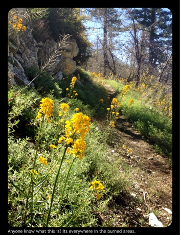
Around mile 413 there was supposed to be a detour around some of the area burned in the station fire, but when I got there all the footprints led down the normal trail, and there were no signs about the detour, so on I went. The trail wrapped around a finger like point jutting north out towards the desert, then really started heading down. It was really interesting to see how this area is recovering from the fire. The shrubby understory has grown back thick, and wild flowers completely cover the ground in places. The bird abundance and diversity was also quite impressive, with lots of Lazuli Buntings and Bluebirds and Wood-pewees and many more. Down lower some new pine trees were already 3-4 feet tall.

I was feeling good through the first few miles this morning, but ended up taking it a bit fast and started to feel some tightness in my quad right where I had all the pain before. "Uh oh", I thought as I slowed down, "this is going to be a long day." I eased my way on down the hill, managing to not cause much more irritation, but also without any improvement. I eased in to the Mill Creek Fire Station around 8 and settled in to the little hiker day use area where there's A faucet, pit toilet, a couple picnic tables, and a trail registry. I sat drinking water and flipping through the registry, looking for the people I was hiking with before I got off trail. They all passed here 12-14 days ahead of me, which is a bit less than I was expecting; I guess the wether just after I got off must have caused some delays.
I ate and stretched and walked around testing the leg then did those things all again. I debated whether it might be best if I just stayed here for the day, rather than risk further inflammation and irritation. In the end I decided to push on, and left there around 9:20 for a slow hot climb back up on to the long shoulder of Mount Gleason.my leg still felt a bit off, and it was already in the low 80s, so I took the climb slowly. In two different places a dozen or so feet apart at mile 420 people had arranged rocks to form the numbers and also made little pot leaves and exclamation marks. I wondered if maybe they had been made by the same person, who just forgot quickly that they'd made the first one...
The trail leveled off after a couple miles for the long gradual ascent of Mt Gleason. The trail was well maintained thanks to recent work by a volunteer group, the Southern California Trail Gorillas, and I was able to get into a pretty good rhythm. I hesitate to use words like "Zen" or "meditative" because they probably mean much more than I really understand. But I got into a really interesting mental-physical state where my walking became nearly effortless and I felt like I was just drifting I got in a river of something. I found a rhythm of walking with my arms and hips swinging, and it seemed like there was some sort of conservation of momentum thing going on, like some sort of reciprocating flywheel. I imagine I mint have looked like an extra from a Talking Heads video, but no one was around to ask. I covered the next 6 miles in about 2.5 hours, and made it to mile 427, a bit over 16 miles into the day, by 1 in the afternoon. It was pretty hot now so I decided a siesta was in order. I found a little bit of sparse dappled shade and plopped down, deploying the umbrella for extra coverage, then proceeded with the normal siesta activities. I was so able to talk to Libby for a bit and confirm that there are some new shoes coming to Acton. It was really great to hear her voice to eat through a bit of the loneliness I've been feeling since getting back on trail.

After siesta there was a final climb up past the gentle, park like summit of Mt Gleason, with some live and some burned J. Pines and Douglas Firs. The Doug firs that had been burned but survived were resprouting greenery all along their branches and some on the trunks so the looked all shaggy. Speaking of shaggy, there was quite a bit of Poodle Dog Bush along this stretch of trail. In previous years it's apparently been so bad that people have walked a road to get around it. But with all the recent trail work I had no problem. Thanks Gorillas!!

After crossing just below the summit of Mt Gleason, the trail began a long descent that would eventually lead all the way down to Acton. But my goal for the evening was the next water source at the North Fork Ranger Station, another 6 miles and about 1,800 feet down. This isn't really much elevation drop relative to the horizontal miles, but this section of trail was characterized by long fairly flat stretches then steep drops of a few hundred feet. So I was able to move along at an ok pace for a while, but hen had to slow way down for the steep sections. I managed a pretty good average speed and was also able to enjoy the view quite a bit. It was spectacular, despite the smoggy haze out west. The slope I was descending was the tall wall of a big valley running from the high desert down west toward somewhere. I think when there's rain the Soledad River runs down it. The slope of Mt Gleason on this side drops straight down to the valley, and the trail traces a fairly gradual slope way out and around a side canyon. Down in the valley are rugged and complicated little hills, and along the creek bed there's a green strip of trees.

All day I had only seen 2 other hikers, the fewest I've seen the whole hike, but at the North Fork Ranger Station there were 8 or so hikers hanging out at a couple picnic tables: Ranger, Big Boy Scout, Yesterday, Five Fingers (he's got those shoes), and a few others I didn't catch the names of. We had a pretty fun evening sitting around making jokes. We also hung out with the volunteer who maintains this water source (Ron?), which is several water cooler-type jugs on a picnic table. Most of head other hikers are in heir early 20s, so much of the conversation revolved around various party-type themes, which was fine but got a little old fairly quickly.

There was a warm breeze blowing over the little saddle where this ranger station is, which kept the air nice and fresh as I drifted off to sleep.
Birds:
Common Poor-will
Western Bluebird
Western Wood-pewee
Spotted Towhee
Oregon Junco
Mountain Chickadee
Violet-green Swallow
Northern Flicker
Hairy Woodpecker
House Wren
Western Scrub-jay
Black-headed Grosbeak
Common Raven
Black-chinned Sparrow
California Towhee
American Robin
Ash-throated Flycatcher
Lesser Goldfinch
Lazuli Bunting
Anna's Hummingbird
House Finch
Mountain Quail- fledgling
Sage Sparrow
Wrentit
Bewick's Wren
Orange-crowned Warbler
I enjoyed reading your description of the 'altered state' you were in for part of your hike today!
ReplyDelete